Page Updated:- Wednesday, 24 June, 2026. |
|||||
 Published in the Dover Express, 30 May, 1980. A PERAMBULATION OF THE TOWN, PORT AND FORTRESS. PART 83.
The three streets above named, together with the ~ century-old lanes and courts associated with them, had few historic associations. They were swept away by the Pier Improvement Scheme together with those on the north side named Spring Place and Water Lane. The former was the site of a spring of fresh water which ran into Paradise harbour. After the harbour was transformed into building ground the course of the stream was down Water Lane. It was carried through an arched channel underground, emptying into the tidal dock by the Crosswall.
DRAINAGE WORKS The Dover drainage works were rebuilt in 1925 when the level of land in the Limekiln Street area was raised. The site is near what was formerly called Water Lane, which was a turning off Elizabeth Street alongside Holy Trinity boys’ and girls’ schools. The main sewer, into which converged the whole of the sewage of Dover, was carried into a well at those works and pumped to a level which enabled it to be discharged into the sea via a long outfall sewer midway along Shakespeare Beach. In recent years a modern pumping station was built in Elizabeth Street to replace the old works.
DOVER HARBOUR This chapter deals with the ancient haven, the Eastern harbour, the 16th century Western harbour and its later development, the new commercial harbour and the 20th century Admiralty harbour. Dover's ancient land-locked haven lay in a deep and beautiful valley, the only one on the coast of Kent where the sea was admitted inward of the cliffs. The estuary of the Dour being deep enough for ships of the ancient times to sail in, the mariners found a sheltered anchorage behind the foot of the eastern hill, on the south side of St. James's new church. It was to this landing place that Julius Caesar was steering his ships, on the 25th August, B.C.55. The date is based on astronomical calculations by Dr. Hailey, the Astronomer Royal, in 1691. Caesar wrote in his Commentaries that he was opposed by armed natives who occupied their “high bold shores“ — a phrase which picturesquely indicates a tidal Dour, with Britons on the vantage ground on either side. Caesar’s advance being checked, by the valour of the British forces marshalled on those hills, he cast anchor off the exact spot where the modern town of Dover has been built, to await the flood tide which, later in the day, carried him round the South Foreland to Deal, where he eventually landed.
DOVER A ROMAN PORT The brief visit to Dover haven must have convinced the Romans that a port so commodious and convenient was indispensable, therefore as soon as they established themselves on this island, they made a maritime station here. Sumner, in his Ports and Forts of Kent, wrote: ‘A Roman port it was, and continued afterwards a port through Saxon, Danish, and Norman ages until this present“; and, the old writer adds, that although other ports on both sides of the Channel had, in the “ track of time, been supplanted. Dover remains as of most advantage to the passenger by reason of the greater shortness of the cut between.“ It is easy to imagine the valley of Dover, in the British period, with the tide flowing up as far as Charlton Green, the wide expanse of land-locked waters rendered picturesque by the tawny sails of the home craft and those of the Belgic people, who, before the days of Caesar, had largely migrated here, and were frequently sailing to and fro between this haven and their native land. This, the only secure place on the south-east coast for landing and lying at anchor, made Dover important to those far-distant times, giving it the character ascribed to it, paraphrasing Caesar’s words, as "the civilest place in all this isle.“ Those early messengers of commerce would be more frequent in their visits after the Roman occupation, when the blazing beacon towers on the eastern and western heights, made it easier and safer to reach this fair haven.
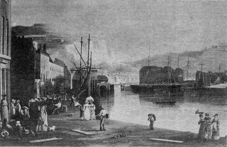
A charming picture of the 1820s, giving a view from Custom House Quay of the Granville Dock and the old entrance to the Wellington Dock. This was in the decade before the advent of regular steamer crossings of the Channel. The picture is a copy of an engraving published by Ackermann’s Repository of Arts, in London’s Strand.
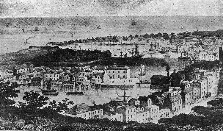
The picture above, also from an engraving, is a bird’s-eye view of the densely populated Pier District in 1835. It also depicts the old entrance from the Granville Dock into the Wellington Dock. Interesting features are the heavily built-up Union Quay, in the centre, and the number of properties between the Sea Front and the Crosswall.
|
|||||
|
If anyone should have any a better picture than any on this page, or think I should add one they have, please email me at the following address:-
|
|||||
| LAST PAGE |
|
MENU PAGE |
|
NEXT PAGE | |