Page Updated:- Wednesday, 24 June, 2026. |
|||||
 Published in the South Kent Gazette, 12 March, 1980. A PERAMBULATION OF THE TOWN, PORT AND FORTRESS. PART 66.
Finnis’s Hill is an offshoot of Limekiln Street. Here was established, about the year 1834, the Dover British Schools, which did good work for about fifty years, after which they were closed and sold. Much property was pulled down before the first world war and, at the bottom, facing the Viaduct, was built Holy Trinity Parish Hall as a War Memorial.
THE OIL MILLS One of Dover’s extinct big industries — oil-seed crushing and the manufacture of vegetable oil and oil-cake for cattle, etc. — was carried on for many years in the extensive building still standing under the cliff on the west side of the railway. A slice of Oil Mill history will come in appropriately here. About 1826, the site under the cliff was occupied by Becker's steam corn mill, which was one of the wonders of the Pier district. That mill, in the course of time, became the property of Mr. Joseph Walker, who transformed it into the Dover Oil Mills. Before the present Dover Waterworks were established by the Corporation, there were two sources of supply in Dover, called the Eastern and the Western Waterworks. The eastern works were carried on by the Gas Company at East Cliff and the Oil Mills constituted the Western works. These mills were enlarged and extended in every possible direction when Mr. Walker was successfully running them, in the 1850s, and although the structural parts may have been a little heterogeneous, the machinery, plant, and working formed a practical exhibition of advanced skill and science. In the year 1853 about midnight, on the 14th of August, an immense conflagration broke out destroying the whole concern, and doing damage to the extent of £45,000. After that, the place was re-built on a much improved scale, as far as architecture is concerned, and the works were taken over by the Dover Oil Seed Crushing Company, which continued their operations until 1889, the competition of foreign imports causing their failure. After that the buildings were empty for years. Temporary use was made of them about 1900 to house workers when Messrs. Pearson were building the Admiralty Harbour. The mills also were in use for a time by Messrs. Wiggins, Teape and Co., in 1906, when a big fire destroyed their Crabble Mills. During the War of 1914-18, the mill buildings were used as barracks, and the huge caves in the cliff at the rear became air-raid shelters. After the war the premises were used for a short time, from 1923, as a garage for the Cambrian motor coaches. After this there were a number of owners and the buildings were put to a wide variety of uses until they were destroyed in May 1965 in what was probably one of the biggest fires in Dover since the Normans burned the town at the Conquest of 1066. The buildings were then known as Commercial buildings, housing a number of factories The buildings were gutted and damage and losses were put at around £1 million.
ARCHCLIFFE ROAD Bulwark Hill, later known as Archcliffe Road, which, in 1934, the Town Council arranged to widen, was a short thoroughfare rising out of Limekiln Street; and, although having few houses, its associations were unusually interesting. The physical features of the place are as old as the hills, but as a place of habitation it cannot claim anything more remote than the time of Henry VII. The Pier Council School for Infants, on the cliff side of the road, near the top, was built in 1911-12.
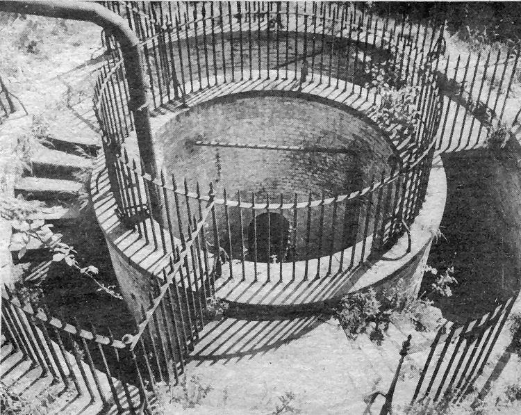
The Grand Shaft — linking Snargate Street with the Western Heights is regarded as a unique piece of military engineering. It has a triple stairway — the three entrances to which can be seen in this picture — and was built during the days of threats of Napoleonic invasions. The idea was that troops stationed in underground casemates on the Western Heights could use the stairways to rush down to near sea level to attack any French beach head. The attraction of the Grand Shaft has been acknowledged by Dover District Council, Kent County Council and the Department of Environment who have shared the cost of the recent restoration. The New Dover Group and others have campaigned to make it a tourist attraction.
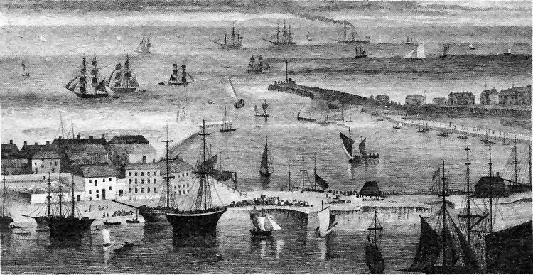
This interesting picture, from a George Shepherd drawing published as an engraving in 1830, is worth comparing with the 1739 Buck print in Part 64. In the centre are the North and South Piers with the Crosswall in the foreground separating the old Pent or Granville Dock as it is now known from the tidal dock inside the piers. In the centre of the Crosswall is the lock gate entrance to the Granville Dock.
|
|||||
|
If anyone should have any a better picture than any on this page, or think I should add one they have, please email me at the following address:-
|
|||||
| LAST PAGE |
|
MENU PAGE |
|
NEXT PAGE | |