Page Updated:- Wednesday, 24 June, 2026. |
|||||
 Published in the South Kent Gazette, 24 October, 1979. A PERAMBULATION OF THE TOWN, PORT AND FORTRESS. PART 30.
“A PUBLIC QUARRY.“ One of the properties which has disappeared from Chapel Place due to redevelopment showed signs of great antiquity. Standing on the east side it was markedly different to the houses surrounding it which were obviously built largely with materials obtained from the old town wall. This ancient building, of brick, was probably built before the ruins of the wall were available as a public Quarry. It appeared from its situation to tally with “a messuage“ mentioned in an indenture which is preserved amongst the Dover Corporation muniments dated 20th November, 1551, in which it is stated that Robert Justice. Mayor, with the assent and consent of the whole Commonalty, let the messuage and appurtenances to Thomas Finett, one of the Jurats, its situation being described —“In Bourman's Ward, to wit, abutting on the one side of the King’s road, leading above the wall of the town, called ‘Above Wall,’ to the south-east, bordering the said town wall to the south-west, . . . and bordering on the lane called Bourman’s Lane (i.e., Last Lane) to the north-east.“ A house in exactly the same situation is also mentioned in a deed dated the 20th October, 1524. This appears to have been the only house of any importance in the “Above Wall“ locality at that time, for a deed of 1569 particularises the “Above Wall“ holdings nearly all of which were land, the holders being Alexander Mynge, one of the Jurats, Thomas Pepper, Mayor in 1559-65-67, and two others. One portion of this “Above Wall“ land was the property of the Maison Dieu, and is so mentioned in a deed dated 1474; but a deed in the reign of Henry VIII describes at as being the property of the King.
LOST OPPORTUNITY. Until the Hitler war and the bombing and shelling which led to demolition and redevelopment which changed the character of the area, the whole of the available building land “Above Wall“ was covered with houses which appeared to have been built without much interference from the local authorities. Somewhat cramped in places they did, however, have the advantage of being in an elevated position. If the builders at the beginning of the last century had been endowed with a little foresight and enterprise, Adrian Street, instead of being occupied by cheap cottages mostly constructed of debris from the town wall, might have been a fine terrace overlooking the sea, like The Leas at Folkestone. Towards the lower end of Adrian Street, very near to where the old gate called Upwall stood, stood St Mary’s Mission Hall, built in the time of the late Canon Puckle, for promoting the spiritual enlightenment of this district. A little way along from Chapel Place is the Unitarian Church, built in 1820 as the successor of Captain Taverner’s place of worship in Market Lane. Adjoining it, actually in Chapel Place, is the modern church hall.
COWGATE CEMETERY. At the top of Adrian Street is Adrian Row, a sunny spot open to the free air that blows over the Western Heights, and here Mr. A. White built on the sites of some old cottages “Albany Flats“ which were considered a good class of artizans’ dwellings. Facing the site of these are the sixty-four steps, leading up to the Drop Redoubt, on the Western Heights, from which one of the best views of Dover may be obtained. On the north of the steps is Cowgate Cemetery, opened for St. Mary’s Parish in 1835, when the old St. Martin’s Cemetery was closed. This land, consisting of 2½ acres, was the property of the Archbishop of Canterbury, who gave it for a burial place. In this much overgrown and neglected cemetery many of the men who were the leaders in Dover during the first half of the 19th century, lie at rest. An interesting obelisk there which was financed with money raised by penny subscriptions is to the memory of Sergeant Monger, who was killed by the bursting of a gun at Archcliffe Fort when exercising as a volunteer, on 9th July 1860. Buried with full military honours his funeral is the subject of an early photograph.
BETSY TROTWOOD’S COTTAGE. In this “Above Wall“ district was said to be situated Betsy Trotwood’s cottage mentioned in “David Copperfield.“ It was said to be near the old Pilot’s outlook, or watch tower, which used to occupy the edge of the cliff at the top of Adrian Street before the Pilot Tower was built adjacent to Southern House — formerly the "Lord Warden Hotel." Dickens described it as “a very neat little cottage with cheerful bow windows: in front of it a small square gravelled court or garden full of flowers.“ Near the top of Adrian Street, hidden by a house built in front there was a cottage answering that description until well into the 20th century.
QUEEN STREET. Queen Street extends westward from the centre to the extremity of ancient Dover. Although centrally situated, Queen Street has but few ancient associations, nor is it mentioned in the charters and deeds. It lies in the old St. George’s and Bourman’s Wards, as those divisions of the town existed prior to the rearrangement of the Wards in the reign of James I.; and when St. Martin-le-Grand existed as a monastery this thoroughfare, now called Queen Street, was a lane, chiefly margined by fields, forming a sort of “town and gown“ boundary dividing the trading part of the town from the monastic precincts. The lower part of Queen Street is narrow. Its improvement was discussed by the Paving Commissioners from 1828 to 1836, but when the new King Street frontage was built on its present line the cramped entrance to Queen Street discouraged all later attempts to improve the thoroughfare. There have been many changes in this street. In very early times, buildings occupied by the Canons of St. Martin’s stood here, and the land continued to be the property of St. Martin’s Priory, until the dissolution of religious houses in the reign of Henry VIII. After that it passed, by a process never exactly explained, into the possession of James Hugessen, a merchant adventurer, of Dover, and eventually, in the year 1633, by deed of gift, to the Corporation.
ST. MARY’S SCHOOL. Hereabouts, in a part of the old buildings of St. Martin-le-Grand, which had been used as a Court Hall, Mr. Robert Udney, in the year 1616, kept a school, receiving from the Corporation a salary of £8 a year, for giving free education to six poor children of the town. This charity school, built in 1789, was the forerunner of the old St. Mary’s primary school, built on the seaward side of Queen Street in 1820, which was eventually demolished along with properties on the other side of Queen Street, above the old covered market, to make way for the construction of the York Street dual carriageway. Dover has long been noted for its seminaries and academies for young people.
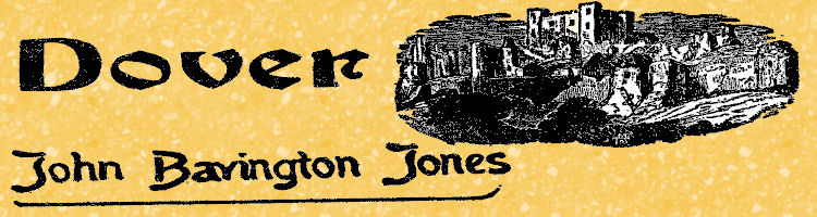
One of the ancient cottages which used to stand in Snargate Street. Probably dating from the 16th century it was sketched by Thomas Hastings, an etcher and engraver, between 1821-24. The picture is one of 36 drawings by Hastings and about 40 watercolours by S. J. Mackie, dating from the 1840s, which form the Lord Astor of Hever Collection presented to Dover museum in 1963 by R. B. Dunwoody, of Tadworth, Surrey. The bequest was to commemorate the representation of Dover in Parliament, from 1922-45, of Lord Astor, who was then Major Astor.
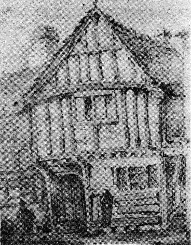
A stage coach trundles along old Snargate Street in this attractive and rare engraving of the early 1800s.
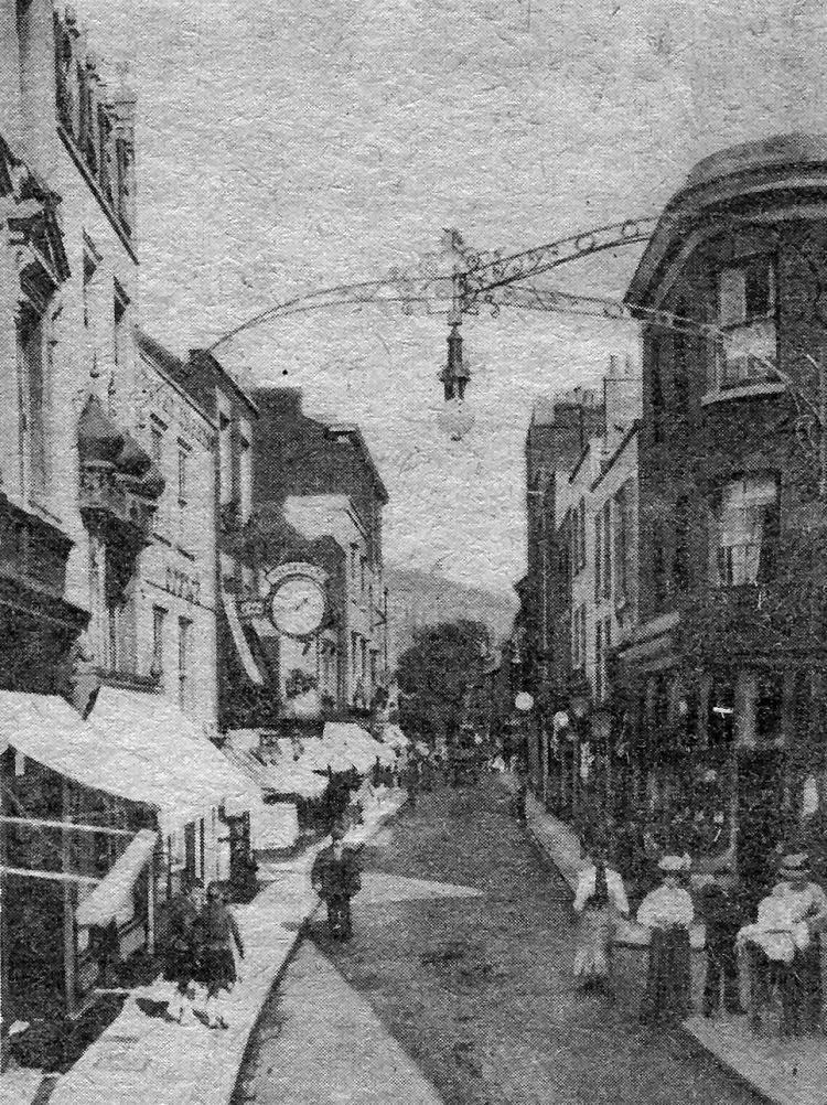
Above is a postcard view of the street, looking in the opposite direction towards New Bridge a hundred years later. Interesting features are the street lamp suspended from ornate wrought iron brackets mounted on three separate buildings and Igglesden, the watchmaker’s clock projecting over the pavement next to the old Dover Express office on the left. Next door was Cave’s Oriental Cafe and opposite, on the corner of Wellington Passage, the shop of a general dealer who appears to have doubled as a pawnbroker.
|
|||||
|
If anyone should have any a better picture than any on this page, or think I should add one they have, please email me at the following address:-
|
|||||
| LAST PAGE |
|
MENU PAGE |
|
NEXT PAGE | |